|
|
|
What is Europe?
From Wikipedia, the free encyclopedia:
Europe is conventionally considered one of the seven continents of Earth which, in this case, is more a cultural and political distinction than a physiographic one, leading to various perspectives about Europe's borders. Physically and geologically, Europe is a subcontinent or large peninsula, forming the westernmost part of Eurasia and west of Asia.
Europe is bounded to the north by the Arctic Ocean, to the west by the Atlantic Ocean, to the south by the Mediterranean Sea, and–according to the traditional geographic definition–to the southeast by the waterways adjoining the Mediterranean to and including the Black Sea, and the Caucasus Mountains. Europe's eastern frontier is vague, but has traditionally been given as the divide of the Ural Mountains and the Caspian Sea to the southeast. The Urals are considered by most to be a geographical and tectonic landmark separating Asia from Europe.
Europe is the world's second-smallest continent in terms of area, covering about 10,390,000 square kilometres (4,010,000 sq mi) or 2.0 % of the Earth's surface. The only smaller continent is Australia. In terms of population, it is the third-largest continent (Asia and Africa are larger) with a population of more than 710,000,000, or about 11 % of the world's population.
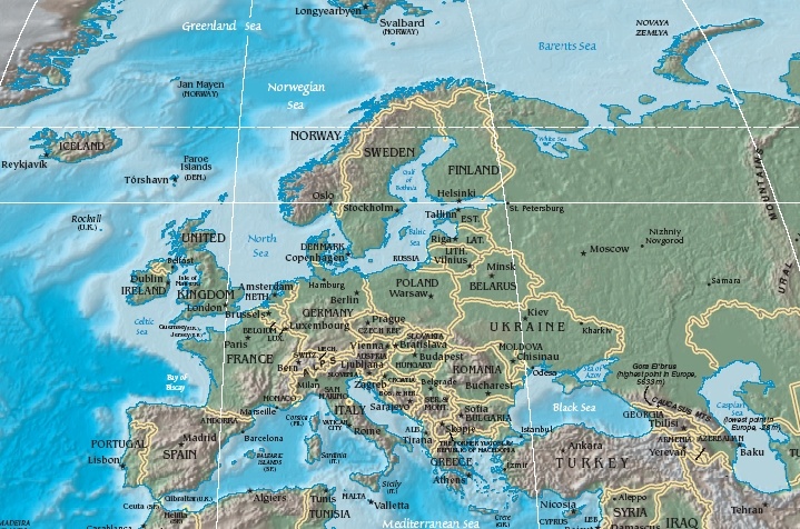
Political map
Etymology
In Greek mythology, Europa was a Phoenician princess who was abducted by Zeus in bull form and taken to the island of Crete, where she gave birth to Minos. For Homer, Europé (Greek: Ευρωπη) was a mythological queen of Crete, not a geographical designation. Later Europa stood for mainland Greece, and by 500 BC its meaning had been extended to lands to the north.
The Greek term Europe has been derived from Greek words meaning broad (eurys) and face (ops) -- broad having been an epitheton of Earth herself in the reconstructed Proto-Indo-European religion. A minority, however, suggest this Greek popular etymology is really based on a Semitic word such as the Akkadian erebu meaning "sunset". From the Middle Eastern vantagepoint, the sun does set over Europe, the lands to the west. Likewise, Asia is sometimes thought to have derived from a Semitic word such as the Akkadian asu, meaning "sunrise", and is the land to the east from a Middle Eastern perspective.
History
As part of the Old World, Europe has a long history of cultural and economic achievement, starting as far back as the Paleolithic. The recent discovery at Monte Poggiolo, Italy, of thousands of stones shaped by human hands, and tentatively dated to 800,000 years ago, may prove to be of particular importance, though the origins of modern Europeans are much more recent.
The origins of Western democratic and individualistic culture are often attributed to Ancient Greece, though numerous other distinct influences, in particular Christianity, can also be credited with the spread of concepts such as egalitarianism and universality of law.
The Roman Empire divided the continent along the Rhine and Danube rivers for several centuries.
Geography and extent
Europe at its furthest extent, reaching to the Urals.
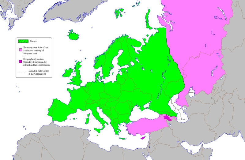
Geographically, Europe is the western portion of the larger landmass known as Eurasia. The continent begins at the Ural Mountains in Russia, which define Europe's eastern boundary with Asia. The southeast boundary with Asia is not universally defined. Most commonly the Ural or, alternatively, the Emba River serve as possible boundaries. The boundary continues to the Caspian Sea, the crest of the Caucasus Mountains or, alternatively, the Kura River in the Caucasus, and on to the Black Sea; the Bosporus, the Sea of Marmara, and the Dardanelles conclude the Asian boundary. The Mediterranean Sea to the south separates Europe from Africa. The western boundary is the Atlantic Ocean, but Iceland, much farther away than the nearest points of Africa, is also often included in Europe.
Due to sociopolitical and cultural differences, there are various descriptions of Europe's boundary; in some sources, some territories are not included in Europe, while other sources include them. For instance, geographers from Russia and other post-Soviet states generally include the Urals in Europe while including Caucasia in Asia.
Almost all European countries are members of the Council of Europe, the exceptions being Belarus, and the Holy See (Vatican City).
The idea of the European continent is not held across all cultures. Some non-European geographical texts refer to the continent of Eurasia, or to the European peninsula, given that Europe is not surrounded by sea. In the past, concepts such as "Christendom" were deemed geographically definitive.
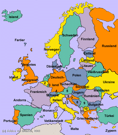
In another usage, Europe is increasingly being used as a short-form for the European Union (EU) and its members, currently consisting of 25 member states and the candidate countries negotiating for membership, and several other countries expected to begin negotiations in the future (see Enlargement of the European Union). This definition, however, excludes non-members such as Switzerland and Norway.
The Asia-Europe boundary
The nature and boundaries of Europe are as much sociopolitical questions as geographical. Many geologists and geographers agree that Europe and Asia share many common geographical features and they are sometimes referred to as the single continent Eurasia. Europe is nevertheless a distinct geographical entity, a peninsula off the mainland of Asia.
The eastern boundary of Europe has been variously defined since antiquity. Herodotus regarded Europe as extending all the way to the Eastern Ocean, and therefore being as long as (and much larger than) Africa and Asia together. The modern world is in consensus that Europe ends at the Aegean Sea, the Black Sea and the Ural Mountains, but the boundaries between these later two features are uncertain; that leading from the Urals to the Black Sea, for example, has been drawn by different authorities as at the Don, the Kuma-Manych Depression, the Caucasus, the Russian frontier or the Phasis.
Numerous sources (e.g. the National Geographic Society) state that the Europe-Asia boundary follows the watershed of the Ural Mountains from near Kara, Russia on the Kara Sea to the source of the Ural River, then follows that river to the Caspian Sea, the watershed of the Caucasus Mountains, and the Black Sea (This is also the definition used in this book series.). These sources focus mostly on state borders, political affiliation and cultural affiliation.
Others instead discuss the following, more geographicaly-focused, path: from Baydaratskaya Guba on the Kara Sea, the border follows the eastern side of the Ural mountains, then the Ural River until the Mugodzhar Hills, then the Emba River to the Caspian Sea. The Caspian section of the border goes through the deepest parts of the sea, then on the Kura River (in Azerbaijan and Georgia), through the Surami passage, and on the Qvirila river in the Kolkhida lowland to the coastal city of Poti. The Black Sea section of the border again follows the deepest troughs, then through the Bosporus and the Dardanelles, then the deepest parts of the Mediterranean Sea and on to the Strait of Gibraltar.
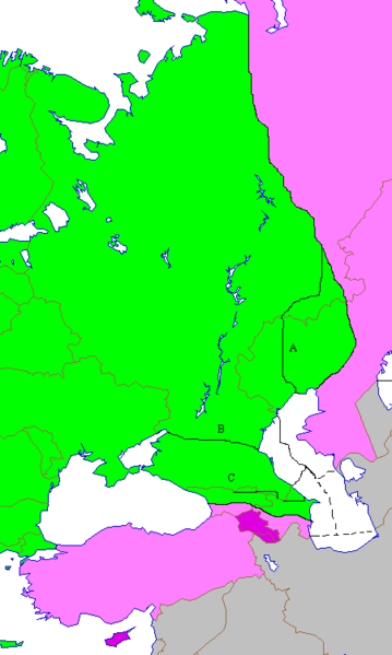
Green - Europe; pink/gray - Asia; A/B/C - other border definitions
By this definition, Europe includes all the Ural Mountains and the Greater Caucasus (not least Mount Elbrus, which would be the highest point in Europe), while the Lesser Caucasus are located entirely in Asia. Russia and Kazakhstan have both European (western) and Asian (eastern) parts. The Turkish city Istanbul lies in both Europe and Asia; effectively making it a transcontinental city. Georgia's capital Tbilisi is located exactly on the border by this definition, while its south-eastern city Rustavi and Azerbaijan's capital Baku are both in Europe. By this definition, the Georgian republics South Ossetia and Abkhazia lie entirely in Europe, but Azerbaijan's exclave of Nakhichevan is located entirely in Asia.
The three additional lines on the map show common interpretations about the border that are mostly non-geographicaly grounded:
— The line labelled A on the map follows the peaks of the Urals, and then the Ural River (some non-geographic sources instead choose the frontier of Kazakhstan, although a natural feature is the only possible geographical boundary as opposed to a political boundary)
— Line B passes through the Kuma-Manych Depression (this path was proposed in 1730 by Philip Johan von Strahlenberg and was adopted then by Tsarina Anna I of Russia. This path would exclude from Europe not only the Caucasus, but also regions traditionally in European Russia such as Krasnodar, with its port on the Black Sea at Novorossiysk)
— Line C follows the Caucasus watershed.
Because of Kazakhstan's Central Asian culture and political orientation, it is very rarely regarded as a European country, despite its sizeable territory in Europe (larger than the whole of Portugal or Greece). Three nations of the South Caucasus, however – Georgia, Azerbaijan and Armenia – have a stronger sociopolitical claim to be European. Of these three, only Georgia and Azerbaijan are sometimes regarded as having small portions of territory in Europe, but Armenia may be regarded as European for cultural and historical reasons.
By this definition, the majority of Georgia's and Azerbaijan's populations live in Europe, and two-thirds of the Georgian territory and a little less than half of Azerbaijan's territory are in Europe. However, they are often excluded today from lists of European states (unlike Russia and Turkey, with proportionally less European territory and population). This may be due in part to the popular Western understanding that, following the dissolution of the Soviet Union, three kinds of state emerged: Russia itself; the "European" states (i.e. the Baltic States, Belarus, Ukraine, and Moldova); and "other, Asian" states. Recent maps, therefore, often fail to distinguish between the South Caucasus states and those of Central Asia.
Political geography
Languages and cultures
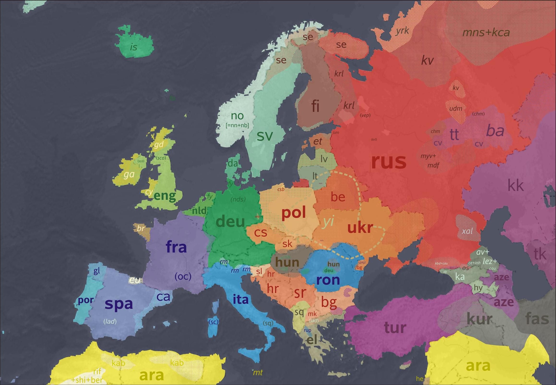
Map showing the approximate current distribution of languages in Europe.
Religions
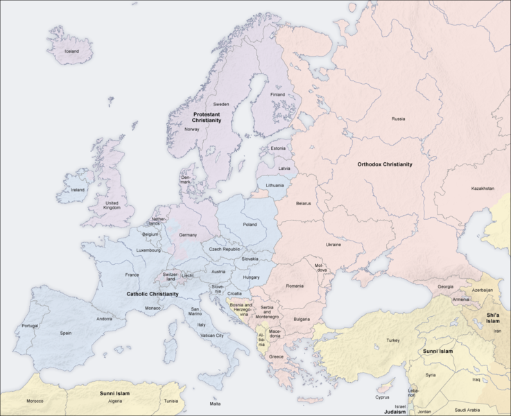
Distribution of religions across Europe
|
|